
Discovery Trail of Wentzwiller
Duration: 1 hour 30 minutes - Easy - Departure from the Church Square parking lot

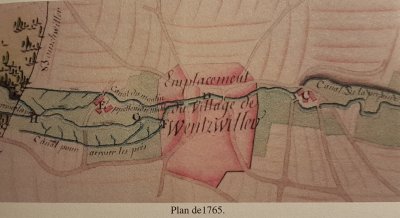
The origins of Wentzwiller date back to the end of the 6th century, and its name, "Wernerswilre," was first mentioned in 1144 in a document from the Bishopric of Basel.
Nestled in the peaceful wooded valley of Altenbach, Wentzwiller has evolved from a rural and agricultural community into a pleasant living environment surrounded by meadows and forests, for the "rurban" residents who now live here.
The village houses are modest, and its church boasts the only half-timbered bell tower in Sundgau. Its history is marked by the events that the Three Borders region has witnessed.
This trail consists of 8 stations that will reveal some traces of its history through the signposts along the way, providing explanations and illustrations.
You can easily follow the trail by following the  orange sign.
The History
The inhabitants of Wentzwiller are sometimes called "Heïla" (the owls) : The neighboring municipalities of Wentzwiller and Buschwiller were disputing the ownership of a very large oak tree that had grown on the border of their communal lands. To settle the dispute, it was decided to cut down the tree and that its wood would belong to the municipality on whose side it fell. The tree fell on the side of Buschwiller, except for a large branch that housed an owl's nest. Since then, the inhabitants of Wentzwiller have been nicknamed "Heïla."
Acknowledgments
![]()
The trail was conceived and realized by residents of the village, who formed an association under WentzAnim, with the participation of the children from Les Lilas school and the local history society le Cercle du Buchholz. Its implementation was made possible thanks to the support of the municipality and the funding from the Région Grand Est, the Collectivité Européenne d’Alsace, and the Crédit Mutuel de Hésingue et environs*.